top-news
Is the Taklamakan Desert Turning into a "Wet Desert"? Expert: Coexistence of Flood and Drought Is Its True Feature
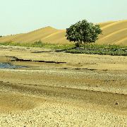
In recent days, areas along the southern edge of the Taklamakan Desert in Xinjiang — Hotan and Qiemo County in Bayingolin — have experienced extreme rainstorms. Heavy precipitation triggered flash floods, with muddy floodwaters overflowing roads along the desert's edge and low-lying barren areas. Images of "flood in the desert" swept across social media, sparking widespread discussion: "Is the desert becoming wetter, and could it even turn into a vast oasis?"
Is the "dry desert" really about to become a "wet desert"?
On June 26, 2026, Wang Hui, a senior engineer at the Xinjiang Climate Center, told media that the warming rate in Xinjiang is 0.33°C per decade, higher than the national average. The average annual temperatures in southern Xinjiang in 2022, 2024, and 2025 tied for the highest since 1961. The average annual precipitation in Xinjiang and southern Xinjiang has increased by 7 mm and 4 mm per decade, respectively.
"The data shows that precipitation in Xinjiang is increasing. But simply saying the region is 'getting wetter' would be inaccurate," Wang Hui said.
Data shows that from 1991 to 2020, the average annual precipitation in Xinjiang increased by 19.4% compared to the previous 30 years, with the most significant increases in the western mountainous areas of southern Xinjiang. However, the current average annual precipitation in southern Xinjiang is only 68.7 mm — far below the national average of 639.6 mm and the Xinjiang-wide average of 177.9 mm.
"Southern Xinjiang remains a typical arid region. An increase of 4 mm per decade cannot change its arid climate pattern," Wang said. Over the past 30 years, the frequency of heavy rain events in southern Xinjiang has increased by about 27% compared to 1961–1990, and heavy snow events have increased by about 1.5 times. However, the number of annual precipitation days in Xinjiang has changed very little, meaning the increase in annual precipitation is mainly driven by more extreme heavy rainfall.
The Taklamakan Desert lies at the center of the Tarim Basin in Xinjiang, spanning Bayingolin Mongol Autonomous Prefecture, Kashgar, Hotan, Aksu, and other areas. It is China's largest desert, the world's tenth largest, and the second-largest shifting sand desert. For a long time, it has been characterized by extreme aridity and scarce rainfall. This rare flood event has shattered the public's conventional understanding of the desert.
Li Ruqi, chief forecaster of the Xinjiang Meteorological Observatory, explained that the sudden rainstorm in the arid desert zone was primarily driven by special moisture transport and topographic conditions.
"Low-level easterly winds enter the southern Xinjiang basin from the east and move westward along the Kunlun Mountains, while mid-level warm, moist air crosses from the northwestern corner of the Qinghai-Tibet Plateau. These two currents converge along the mountain slopes, where topographic uplift occurs. Combined with surface heating that intensifies the temperature difference between upper and lower altitudes, atmospheric convective dynamics are greatly enhanced. Under the combined influence of circulation, moisture, thermal, and dynamic conditions, this extreme precipitation event was formed," Li said.
The Paper noted that in recent years, Xinjiang has seen alternating episodes of extreme precipitation and extreme drought. In 2020, northern Xinjiang experienced its strongest spring-summer drought since 2000, and in 2022, northern and eastern Xinjiang suffered a similarly severe drought from late spring to early autumn. Meanwhile, extreme rainstorms in southern Xinjiang have repeatedly broken records.
Flooding in the Taklamakan Desert is not an altogether rare phenomenon. The Tarim River and its upstream tributaries, such as the Hotan River and the Yarkand River, often experience snowmelt floods that overflow their banks into the desert.
In July 2021, the Yuqi area of Sinopec's Northwest Oil Field, located in the Taklamakan Desert, was hit by floods, with an inundated area spanning over 300 square kilometers. In the summer of 2022, 21 rivers — including the main stream of the Tarim River and its tributaries, the Yarkand, Aksu, and Weigan Rivers — experienced floods exceeding warning levels. The flood process on the Tarim River's main stream lasted 80 days, finally ending on September 22.
"Xinjiang's climate is not simply 'getting wetter.' Instead, extreme weather events are becoming more frequent. The coexistence of flood and drought is its true feature," Wang Hui concluded.